Rope access technique level 1 and 2

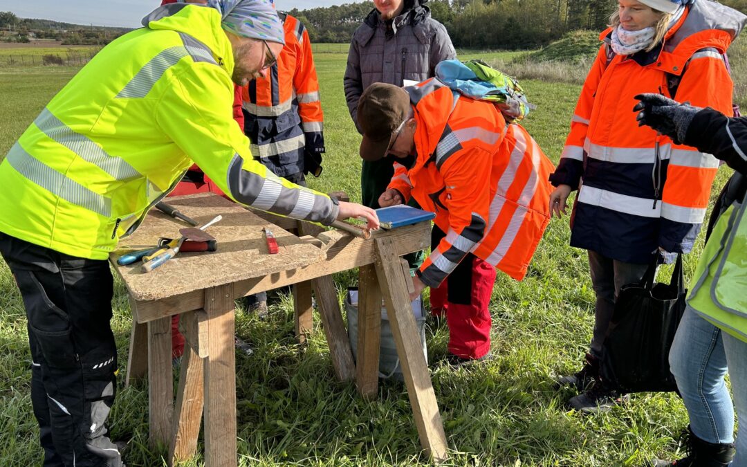
Ropedancing under the bridge: LGA rock team completes training as rope access technicians level 1 and 2

Posted on 21 December.

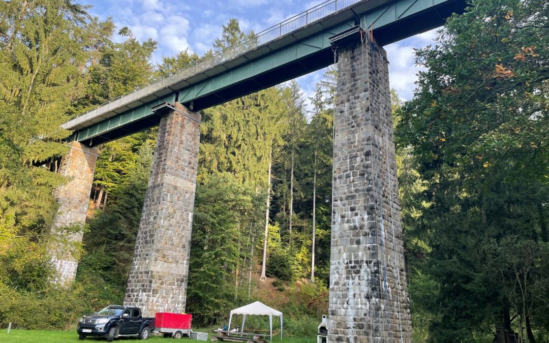
It’s actually a lovely spot, reminiscent of a vacation: the Menach meanders through the green meadow. An old, disused railroad bridge, over which occasionally a cyclist rides. The training site in Mitterfels near Straubing invites you to rest and relax. But that’s not what the LGA rock team has come for. On the agenda is a tight training program from 10-12 and 23-27 October, which will train participants to become rope access technicians level 1 and level 2.

Training location in Mitterfels

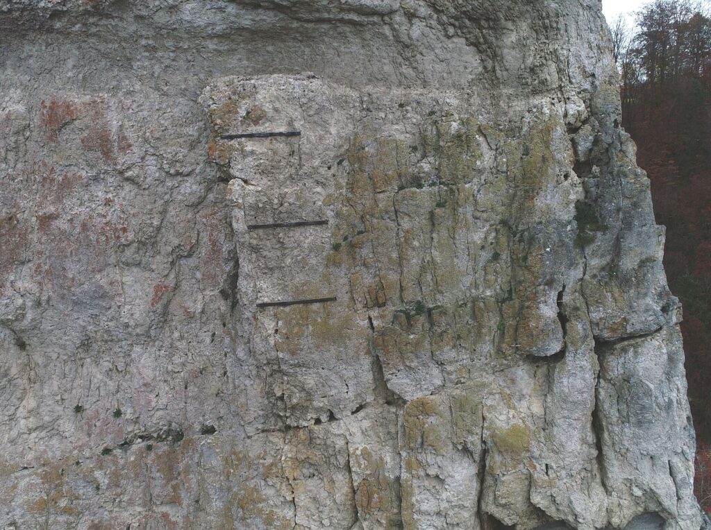
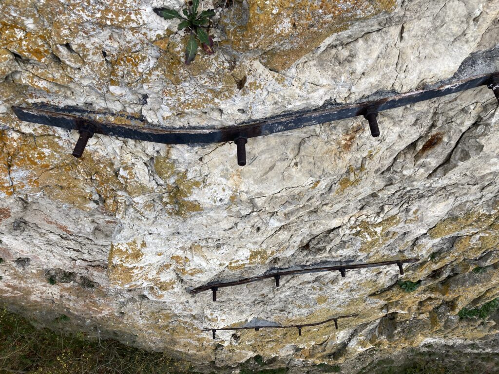
The assessment of rocks with the aid of rope access technology (SZT) is an essential part of the rock team’s work. Rocks often cannot be adequately inspected from the ground or by drone because they are difficult to see or details such as the fracture pattern cannot be examined from a distance. In order to be able to assign a well-founded risk level to rock massifs and plan adequate safety measures, a thorough and object-oriented examination using SZT is used. Rope access has little to do with sport climbing. Instead of climbing the rock themselves, the experts use personal protective equipment (PPE) to abseil down or climb up two ropes.

Climbing up the rope under the watchful eye of the instructor

For nine years, the LGA’s rock experts have been trained annually in the use of PPE specifically for use in rock assessments. This year, Christoph Rieser, instructor of the Association of German Mountain and Ski Guides (VDBS), has chosen the natural stone bridge pillars in Mitterfels as the training site for the rope access technician level 1 and 2 training. The program includes both repetition of what has already been learned and the acquisition of new skills: Rappelling and ascending on ropes (vertical direction), rope changes and traverses (horizontal direction), climbing over stands, setting up and using pulleys, various rescue scenarios for rescuing a person who has had an accident, knot tying and theory units, e.g. on material science and fall physics.

Rescue exercise: rescuing an accident victim downwards

On the last day of each of the two training blocks, a theoretical and practical examination took place, which was taken by the state-certified mountain and ski guide Andreas Schanzer; VDBS, and with the passing of which the participants were awarded Level 1 (10.-12.10.) and Level 2 (23.-27.10.).

We are delighted to have been accepted into the VDBS as rope access technicians and would like to thank Christoph Rieser and Andreas Schanzer for their excellent training.

Transverse route on a steel cable under the bridge at a height of almost 20 m

LGA Institut für Umweltgeologie und Altlasten GmbH

Christian-Hessel-Str. 1
D-90427 Nürnberg

Phone:  +49 911 12076 100
Telefax:  +49 911 12076 110
info@LGA-geo.de
bewerbung@LGA-geo.de

LGA Institut für Umweltgeologie und Altlasten GmbH

Christian-Hessel-Str. 1
90427 Nürnberg

Tel: +49 911 12076 100
Fax: +49 911 12076 110
info@LGA-geo.de
bewerbung@LGA-geo.de

News

Older articles

Successful DAkkS audit

Successful DAkkS audit

Posted on 22 November.

For our evaluations of soil, water, building materials and waste, we value qualified sampling very highly. Our comprehensive quality management system in accordance with DIN EN ISO/IEC 17025:2018 is accredited by the DAkkS (German Accreditation Body) and is regularly reviewed (every 1.5 years) as part of monitoring audits.

A complete review of all sampling procedures and the management system is required every 5 years (“reassessment”, formerly “reaccreditation”).

Measurement setup for water sampling
Taking samples from watercourses
During the audit in July 2023, two DakkS auditors were in the building for two days each and inspected all processes in detail. In a letter dated November 3, 2023, the DakkS confirmed the continuation of our accreditation. Quotes from the audit report:

“All employees authorized to take samples have the necessary skills and abilities to carry out sampling competently and professionally in accordance with standards. The team deployed for soil sampling carries out the technical work in an experienced manner.”

“The employees are characterized by their sound professional training.”

“The basic entrepreneurial family concept is particularly noteworthy. This makes it possible to create a stable, low-fluctuation basis. The resulting continuity is also reflected in the management system, which is actively practiced and continuously developed.”

(DakkS certificate) (Annex to DakkS certificate)


LGA Institut für Umweltgeologie und Altlasten GmbH

Christian-Hessel-Str. 1
D-90427 Nürnberg

Phone:  +49 911 12076 100
Telefax:  +49 911 12076 110
info@LGA-geo.de
bewerbung@LGA-geo.de

News

Older articles

LGA workshop KA5

Equipped with spade and Puerckhauer: Internal LGA workshop for soil recording according to KA5

Posted on 27 October.

On 18th October and 25th October 2023, one group of the LGA team was trained in the preparation, implementation and documentation of the soil recording according to KA5.

The workshop was led by our former colleague Dr. Kunibert Eberlein, an expert in soil science who has been appointed by the former Bavarian Geological Survey (Bayerisches Geologisches Landesamt) as an expert on soil mapping. The Guggenmühle clay pit near Allersberg and a forest area near Buchenbühl were selected as training locations.

The training group on 18th October in the Guggenmühle clay pit near Allersberg

Soil recording is an important tool in soil investigation. Soils are described and classified in terms of various properties and parameters. In order to ensure the comparability and reproducibility of results, the 5th edition of the Soil Science Mapping Guide (KA5) is used as standard for soil mapping. The Soil Science Mapping Guide was first published in 1965 as “Die Bodenkarte 1 : 25 000. Anleitung und Richtlinien zu ihrer Herstellung”. The KA5 is not only used in science for soil mapping, but is also required in various legal standards (e.g. Federal Soil Protection and Contaminated Sites Ordinance, BBodSchV). For example, soil profiles have to be recorded and documented as part of of orienting contaminated site investigations, detailed investigations and remediation investigations.

Martin Kahnt takes a soil sample using a Puerckhauer boring rod

During the one-day workshop in the field, drill cores were taken using a Puerckhauer and small pits were dug in order to visualize the local soil profile. The participants then carried out soil recording for each soil horizon (e.g. finger sample, determination of soil color and substrate identification) according to the KA5 guidelines and recorded the observations on a corresponding form. Kunibert Eberlein explained the individual steps and gave helpful practical tips. The results were discussed at length in the group. Thanks to the workshop, the LGA team was able to deepen its knowledge of the KA5 soil recording. We would like to thank Kunibert Eberlein for his valuable support.

Kunibert Eberlein supervises the training group on 25th October during the soil recording according to KA5

LGA Institut für Umweltgeologie und Altlasten GmbH

Christian-Hessel-Str. 1
D-90427 Nürnberg

Phone:  +49 911 12076 100
Telefax:  +49 911 12076 110
info@LGA-geo.de
bewerbung@LGA-geo.de

News

Older articles

Runoff modeling of heavy rainfall events

Runoff modeling – Valuable forecasting tool for upcoming heavy rainfall events

Posted on 12 June.

Repeated heavy precipitation in 2017 and 2019 led to debris flows in the community of Kauerndorf, which buried the B289 federal road. As a precautionary measure to prevent further debris flows, the construction of an erosion protection construction was therefore planned, which should reduce the catchment area of future heavy precipitation. We were commissioned to prognostically verify the effectiveness of the planned structure. For this purpose, runoff modeling was generated based on the Digital Elevation Model (DTM) with 1-m resolution.

In concrete terms, when calculating a runoff model, sinks without runoff are first eliminated in the DTM (= filled). These are flowed through in reality and would distort the model without correction (= filling). Then, the flow direction of each cell, or square meter, is determined based on the slope. In this way, it is determined into which neighboring cell a drop of water theoretically flows in the cell under consideration. Based on the flow direction, the runoff per cell is finally accumulated. Cells with a high runoff accumulation value are areas where surface runoff is concentrated.

Flow direction and number of cells flowing into each cell
(Source: https://desktop.arcgis.com/de/arcmap/latest/tools/spatial-analyst-toolbox/how-flow-accumulation-works.htm)

In order to verify the effectiveness of the planned erosion protection construction, project manager Thomas Struller set up an investigation concept in which, in a first step, the real runoff conditions are modeled and validated or calibrated on the basis of terrain surveys. In a second step, the terrain surface is manipulated in the model to represent the geometry of the planned construction. Remodeling the runoff conditions with the manipulated surface then shows the runoff after the construction has been built. The difference between the two models can be used to derive the effectiveness of the construction.

According to Simon Landgraf, who performed the modeling and terrain survey, there was no need to calibrate the model. Already the first calculation presented runoff lines that exactly matched the reports of local residents and the event sketches of the debris flows. This high level of agreement is consistent with experience from other projects, in which torrents and mudslides that had already occurred could be reconstructed with meter accuracy by the runoff modeling and thus the source or cause of the event could be determined retrospectively.

Flown through passage

Modeled surface runoff

The second model with incorporated erosion protection construction clearly showed that the runoff formation in the upper slope can be reduced by the construction. There is hardly any surface runoff in this area, which in turn greatly relieves the erosion channel in the lower slope. The effectiveness of the erosion protection construction could thus be prognostically tested and proven.

Result of runoff modeling without erosion protection construction

Result of runoff modeling with erosion protection construction

LGA Institut für Umweltgeologie und Altlasten GmbH

Christian-Hessel-Str. 1
D-90427 Nürnberg

Phone:  +49 911 12076 100
Telefax:  +49 911 12076 110
info@LGA-geo.de
bewerbung@LGA-geo.de

News

Older articles

Inspection of securing constructions

Rockfall protection fence and then what? About the need for regular construction inspections

Posted on 20 April.

High demands are placed on safety constructions (SiBW) against falling rocks and boulders with regard to structural safety, serviceability and durability. It is often forgotten that the construction of rockfall protection fences, meshes, rock nails, shotcrete and the like does not per se provide protection for decades. To reliably fulfill their function, regular inspection and, if necessary, maintenance (servicing) and repair (overhaul) of the SiBW are required.

For inspections, a distinction is made between initial recording, visual inspection, checking, testing and special checking. During the initial recording, the structure is inspected and all data relevant to the construction are recorded on a form. The annual visual inspection is used to check for any events that may have occurred and/or major damage (possibly affecting the serviceability of the SiBW). The visual inspection also serves to check the SiBW for vegetation that would hinder a reliable inspection of the construction in the following year, so that an clearing can be arranged in good time. If, in the opinion of the expert, the serviceability of the SiBW is impaired or an incident is reported, a special check of the SiBW is recommended. The regular inspection in the 5-year cycle replaces the visual inspection in the corresponding year and includes a manual inspection specific to the construction. The inspection in the 15-year cycle replaces visual inspection or checking in the corresponding year. Like the checking, the testing is carried out close to the hand and specific to the construction. In addition, the environment of the SiBW is checked for relevant changes to ensure the continued suitability and serviceability of the SiBW.

Inspection at an old safety construction

The inspections of the past months show the usefulness and necessity of initial recordings and periodical inspections. This year again, numerous “minor” defects were found, ranging from incorrectly installed wire rope clamps and missing components to incompletely filled boreholes with exposed anchors, thus negatively affecting the serviceability of the SiBW. As far as the defects are not due to external influence (missing component, theft, vandalism), experience has shown that they are usually remedied by the construction company at no cost, especially if the defect is claimed within the warranty period.

Incorrectly mounted wire rope clamps

Incompletely filled borehole

Exposed anchor

Other defects, in turn, included severe corrosion on constructions as well as uninspected self-built constructions on rock sections above residential buildings that are at risk of falling. Here, the defects cannot be remedied with simple steps, but the inspection should still not be avoided. After all, the inspection of the condition of a SiBW is closely linked to the question of insurance and liability in the event of personal injury and property damage.

Inspection of a security construction via drone flight

Old metal cramps and rock nails, checking via rappelling

Feel free to contact us when:

  • There are SiBW of unknown age and origin on your parcels of land
  • You are a SiBW owner and have not had any inspections carried out yet
  • You do not know for sure what condition your SiBW is in
  • You wish to ensure that any claims for defects can be asserted before the expiry of the warranty period (in the case of buildings in accordance with VOB/B §13 Para. 4 four years after acceptance of the building)
  • You want a tabular record and spatial location of your SiBW
  • You wish to have an inspection plan for your SiBW for your long term planning
  • You wish to be advised in any other way on SiBW and inspections

LGA Institut für Umweltgeologie und Altlasten GmbH

Christian-Hessel-Str. 1
D-90427 Nürnberg

Phone:  +49 911 12076 100
Telefax:  +49 911 12076 110
info@LGA-geo.de
bewerbung@LGA-geo.de

News

Older articles

Foundation stone laid for Cube One of UTN

Foundation stone laid for Cube One of UTN (University of Technology Nuremberg)

Posted on 21 November.

Since the purchase of the land by the State of Bavaria, the LGA Institut für Umweltgeologie und Altlasten GmbH has accompanied the formation of the UTN – the new Technical University of Nuremberg.

On November 18, 2022, Prime Minister Dr. Markus Söder then laid together with the Science Minister Markus Blume, Construction Minister Christian Bernreiter, the founding president at Nuremberg University of Technology, Prof. Dr. Dr. h.c. mult. Hans Jürgen Prömel, and the Mayor of the City of Nuremberg, Marcus König, the foundation stone for the first building on the campus – Cube One.

The time capsule with photos of the undeveloped area, a streetcar model, a building model and a USB stick with programming code is walled in (from left: Marcus König, Christian Bernreiter, Markus Söder, Markus Blume and Hans Jürgen Prömel)

Dr. Markus Söder – The first step of something big new

Granite plate commemorating the laying of the foundation stone

The foundation stone is laid

The LGA Institut für Umweltgeologie und Altlasten GmbH contributed to the quick realization of the building project with the investigation and remediation of contaminated sites, with the supervision of the site clearance and with the preparation of a contaminated site and subsoil expertise (in cooperation with LGA Baugrund GmbH). Even the radon concentrations in the subsoil were measured by the LGA Institut für Umweltgeologie und Altlasten GmbH investigation department and the radon activity concentrations for the future building were estimated – harmless.

The LGA Institut für Umweltgeologie und Altlasten GmbH was also allowed to participate in the structural planning and in the framework planning for the UTN. Their greatest concern, to prevent senseless soil disposal with gigantic emissions of CO2 and waste of diesel fuel through intelligent soil management, found its way into the planning and was laid down in a progressive soil management concept together with the environmental protection office of the city of Nuremberg. For the construction of Cube One, therefore, only a few hundred tons of soil from a fuel spill had to be disposed of via biological cleaning – a great success for the environment!

LGA Institut für Umweltgeologie und Altlasten GmbH

Christian-Hessel-Str. 1
D-90427 Nürnberg

Phone:  +49 911 12076 100
Telefax:  +49 911 12076 110
info@LGA-geo.de
bewerbung@LGA-geo.de

News

Older articles